
Introduction
 The Earth’s rocky outer crust solidified billions of years ago, soon after the Earth formed. This crust is not a solid shell; it is broken up into huge, thick plates that drift atop the soft, underlying mantle.
The plates are made of rock and drift all over the globe; they move both horizontally (sideways) and vertically (up and down). Over long periods of time, the plates also change in size as their margins are added to, crushed together, or pushed back into the Earth’s mantle. These plates are from 50 to 250 miles (80 to 400 km) thick.
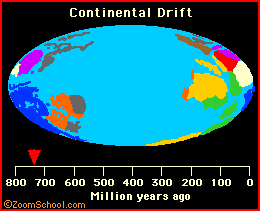
The map of the Earth is always changing; not only are the underlying plates moving, but the plates change in size. Also, the sea level changes over time (as the temperature on Earth varies and the poles melt or freeze to varied extents), covering or exposing different amounts of crust.
Earth’s Major Plates
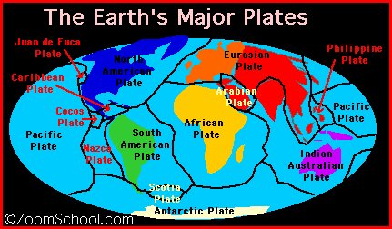
The current continental and oceanic plates include: the Eurasian plate, Australian-Indian plate, Philippine plate, Pacific plate, Juan de Fuca plate, Nazca plate, Cocos plate, North American plate, Caribbean plate, South American plate, African plate, Arabian plate, the Antarctic plate, and the Scotia plate. These plates consist of smaller sub-plates.
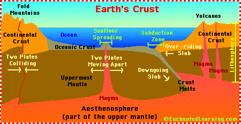
Plate Tectonics
The theory of plate tectonics (meaning “plate structure”) was developed in the 1960’s. This theory explains the movement of the Earth’s plates (which has since been documented scientifically) and also explains the cause of earthquakes, volcanoes, oceanic trenches, mountain range formation, and many other geologic phenomenon.
The plates are moving at a speed that has been estimated at 1 to 10 cm per year. Most of the Earth’s seismic activity (volcanoes and earthquakes) occurs at the plate boundaries as they interact.
| Type of Crust | Average Thickness | Average Age | Major Component |
|---|---|---|---|
| Continental Crust | 20-80 kilometers | 3 billion years | Granite |
| Oceanic Crust | 10 kilometers | Generally 70 to 100 million years old | Basalt |
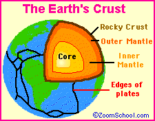
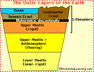 The top layer of the Earth’s surface is called the crust (it lies on top of the plates). Oceanic crust (the thin crust under the oceans) is thinner and denser than continental crust. Crust is constantly being created and destroyed; oceanic crust is more active than continental crust.
Under the crust is the rocky mantle, which is composed of silicon, oxygen, magnesium, iron, aluminum, and calcium. The upper mantle is rigid and is part of the lithosphere (together with the crust). The lower mantle flows slowly, at a rate of a few centimeters per year. The asthenosphere is a part of the upper mantle that exhibits plastic properties. It is located below the lithosphere (the crust and upper mantle), between about 100 and 250 kilometers deep.
Types of Plate Movement
At the boundaries of the plates, various deformations occur as the plates interact; they separate from one another (seafloor spreading), collide (forming mountain ranges), slip past one another (subduction zones, in which plates undergo destruction and remelting), and slip laterally.
Divergent Plate Movement: Seafloor Spreading
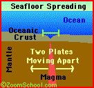
 Seafloor spreading is the movement of two oceanic plates away from each other (at a divergent plate boundary), which results in the formation of new oceanic crust (from magma that comes from within the Earth’s mantle) along a a mid-ocean ridge. Where the oceanic plates are moving away from each other is called a zone of divergence. Ocean floor spreading was first suggested by Harry Hess and Robert Dietz in the 1960’s.
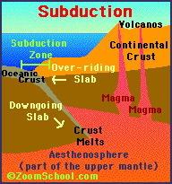
Convergent Plate Movement
 When two plates collide (at a convergent plate boundary), some crust is destroyed in the impact and the plates become smaller. The results differ, depending upon what types of plates are involved.
- Oceanic Plate and Continental Plate
- When a thin, dense oceanic plate collides with a relatively light, thick continental plate, the oceanic plate is forced under the continental plate; this phenomenon is called subduction.
- Two Oceanic Plates
- When two oceanic plates collide, one may be pushed under the other and magma from the mantle rises, forming volcanoes in the vicinity.
- Two Continental Plates
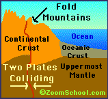 When two continental plates collide, mountain ranges are created as the colliding crust is compressed and pushed upwards.
Lateral Slipping Plate Movement
 When two plates move sideways against each other (at a transform plate boundary), there is a tremendous amount of friction which makes the movement jerky. The plates slip, then stick as the friction and pressure build up to incredible levels. When the pressure is released suddenly, and the plates suddenly jerk apart, this is an earthquake.
Alfred Wegener and Pangaea
 In 1915, the German geologist and meteorologist Alfred Wegener (1880-1930) first proposed the theory of continental drift, which states that parts of the Earth’s crust slowly drift atop a liquid core. The fossil record supports and gives credence to the theories of continental drift and plate tectonics.
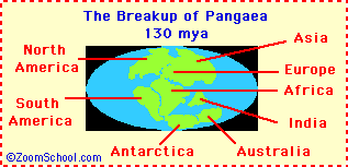 Wegener hypothesized that there was an original, gigantic supercontinent 200 million years ago, which he named Pangaea, meaning “All-earth”. Pangaea was a supercontinent consisting of all of Earth’s land masses. It existed from the Permian through Jurassic periods. It began breaking up during the Jurassic period, forming continents Gondwanaland and Laurasia, separated by the Tethys Sea.
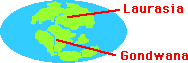 Pangaea started to break up into two smaller supercontinents, called Laurasia and Gondwanaland, during the Jurassic period. By the end of the Cretaceous period, the continents were separating into land masses that look like our modern-day continents.
Wegener published this theory in his 1915 book, On the Origin of Continents and Oceans. In it he also proposed the existence of the supercontinent Pangaea, and named it (Pangaea means “all the land” in Greek).
Fossil Evidence in Support of the Theory
Eduard Suess was an Austrian geologist who first realized that there had once been a land bridge between South America, Africa, India, Australia, and Antarctica. He named this large land mass Gondwanaland (named after a district in India where the fossil plant Glossopteris was found). This was the southern supercontinent formed after Pangaea broke up during the Jurassic period. He based his deductions on the plant Glossopteris, which is found throughout India, South America, southern Africa, Australia, and Antarctica.

Glossopteris, a tree-like plant from the Permian through the Triassic Period. It had tongue-shaped leaves and was about 12 ft (3.7 m) tall. It was the dominant plant of Gondwana.
Fossils of Mesosaurus (one of the first marine reptiles, even older than the dinosaurs) were found in both South America and South Africa. These finds, plus the study of sedimentation and the fossil plant Glossopteris in these southern continents led Alexander duToit, a South African scientist, to bolster the idea of the past existence of a supercontinent in the southern hemisphere, Eduard Suess’s Gondwanaland. This lent further support to A. Wegener’s Continental Drift Theory
Activities/Links
- An interactive quiz about plate tectonics
- A quiz about Continental drift and plate tectonics
- Label the outer layers of the Earth
- Label Seafloor Spreading (Plate Divergence) Label the growth of new oceanic crust as two plates diverge.
- Label Subduction (Plate Convergence) Label the destruction of crust as two plates converge.
- The Ring of Fire